Mapping FAQs
1. How are City Boundary Annexation Ordinances mapped?
The boundaries are mapped using the electronic file provided with the KRS 81A.470 filing by Kentucky Cities. No alterations or adjustments are made when adding or removing areas from the boundary; the area shown in the electronic file is added or removed as provided. If there are gaps between the existing City boundary and the area being annexed there will be gaps in the City boundary after the annexation is added.
2. How often is the mapping updated on the web?
City boundary annexations are continually updated as documents are received from the Secretary of State's Land Records Office. Updates are updated to the web on a weekly basis (updates are made over the weekend).
3. Where can I view City Boundaries online?
An internet mapping site with City Boundaries can be viewed online at: https://kygeonet.ky.gov/kycities/
4. Where can I download the City Boundary GIS data?
City boundaries in GIS ESRI Shapefile format can be downloaded from the Kentucky Geography Network at:
https://ky.app.box.com/v/kymartian-KyBnds-Cities. Please refer to the readmefirst.txt document found with the files for more information.
Electronic Filing Requirements/Surveyor FAQs
5. What are the electronic filing requirements for City annexation or other KRS 81A.470 filings?
An electronic file containing a closed geometric figure depicting the territory being added or removed that is referenced to a Kentucky State Plane Coordinate System zone in any one (1) of the following formats:
1. AutoDesk AutoCAD DWG or DXF;
2. Bentley MicroStation DGN; or
3. ESRI ArcGIS Shapefile.
6. What files make up an AutoCAD, AutoDesk .DWG, .DXF and .DGN file?
There is only one file extension for each of these file types. They must be georeferenced to a Kentucky State Plane Coordinate System Zone
7. What makes up a georeferenced ESRI ArcGIS Shapefile?
A georeferenced shapefile must include as at least 4 file extensions
.shp
.shx
.dbf
.prj
All four files (and any other related files) must be provided. If all the files are not included the file will not work and the filing will be declared unmappable.
Here is a breakdown of each extension
8. What Kentucky State Plane coordinate system should the electronic file be provided in?
According to the Statute: An electronic file containing a closed geometric figure depicting the territory being added or removed that is referenced to a Kentucky State Plane Coordinate System zone.
The electronic file must be referenced to a Kentucky State Plane Coordinate System zone. The 3 Kentucky State Plane Coordinate Systems are 1) Kentucky Single Zone (FIPS 1600), 2) Kentucky North Zone (FIPS 1601) and 3) Kentucky South Zone (FIPS 1602).
9. What happens if an electronic file fails to meet the electronic requirements of KRS 81A.470?
If any of the electronic file requirements are deficient as described above the filing will be declared unmappable and the area will not be updated on the Kentucky Cities interactive map until an electronic file is provided that meets the requirements.
10. How can an electronic file be submitted?
a. Submit a file using the
Kentucky Incorporated City Boundary file submission form
b. Email the file to the Secretary of State Land Office at
Travis.Horn@ky.gov
c. Mail media (i.e., thumb drive or DVD) to the Secretary of State Land Office. Please note this method will delay the mapping process due to delay in transmission through the mail.
11. Where can a surveyor find guidance for meeting the electronic file requirements of KRS 81A.470?
Your software documentation or software support should be able to provide guidance on how to tie into a known coordinate system. The Kentucky Department of Professional Licensing (https://dpl.ky.gov/) and the Kentucky Association of Professional Surveyors (https://www.kaps1.com/) should be able to provide guidance and resources to assist surveyors in meeting the electronic filing requirements.
12. How can a City or Surveyor determine why an electronic file fails to meet the requirements?
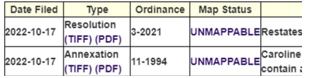
Comments about the Map Status including why a filing is deemed unmappable can be found on the SOS Kentucky Cities website. At the link below search for the City in the search box
https://web.sos.ky.gov/land/cities.aspx
Click on the City name and you will find a list of all filings for the selected City. You will see the ordinances filed along with Map Status and comments. If there are comments regarding the mapping including unmappable filings there will be a hyperlink to Map Status comments as shown below. Review the comments to determine what the deficiency is.

13. What makes an electronic file fail to meet the electronic requirements of KRS 81A.470 thus making it unmappable?
a.
Electronic file provided does not clearly identify the area being described as required by KRS 81A.470. Files that include many boundary lines and other features can make it difficult to determine which lines in the electronic file are the ones being described in the filing. Ideally the only boundary in the electronic file would be the area being added or removed and that boundary would be a single, unbroken line. If significant time or guesswork are required to determine what area should be added or removed the filing will be declared unmappable.
Below is an example of an electronic file that would be
unmappable:

b.
Electronic file provided does not meet the georeferencing requirement of KRS 81A.470. Please note that georeferencing requires tying into a Kentucky State Plane coordinate system (these are listed above). If this is not done the file will not be exported with the georeferenced information required causing it to be
unmappable. The example below shows an electronic file that is placed in Central Africa since it is not in the correct coordinate system.
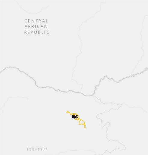
This is of monumental importance because that is what places the ordinance in the correct location on the earth’s surface.
c.
Shapefile does not include all necessary files. See first question on page 1.
d.
Electronic file provided does not meet the file format requirements of KRS 81A.470. Refer to file formats listed in
KRS 81A.470.
14. Although the ordinance was filed by the Secretary of State’s Office and is labeled “Mappable,” the placement needs adjusting. What is the process for correcting existing filings?
The only way to correct the placement of an annexation that has been mapped is to provide an electronic file that meets the current day requirements, see FAQs above regarding electronic filing requirements. Please note that the ordinance to be corrected must be identified and the area to be corrected must match the description provided in the filing or the correction cannot be made.
15. How does a surveyor ensure that no gaps are created when annexations are added to the existing City Boundary?
It is highly recommended that the surveyor download and use the existing City boundary to ensure that areas added to the existing boundary do not create gaps between annexed areas or annex areas that are already part of another City. No alterations or adjustments are made when adding or removing areas from the boundary; the area included in the electronic file is added or removed as provided. If there are gaps between the existing City boundary and the area being annexed there will be gaps in the City boundary after the annexation is added. It is the surveyor’s responsibility to review the current boundary to properly describe the area to be added through the annexation process.